|
⇒ Welcome ⇒ e-mail contact | ||
| ||
| ||
| ||
|
⇒ Cover ⇒ Preface ⇒ Introduction ⇒ The visit ⇒ Weymouth map c.1930 ⇒ Portland map c.1930 ⇒ Works quoted ⇒ Postface |

|
A visit to Weymouth with John Cowper Powys [ ⇒
return... ]
|
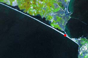
CHESIL BEACHPhotograph of Chesil Beach looking NW towards Bridport as indicated. The word Chesil (circa 1535) comes from the O.E. cisil, ceosel, cysel, (linked with the Ger. kies ) = gravel, shingle. "It is the most remarkable and dangerous beach on the South Coast. It is a long, monotonous ridge of pebbles, and extends from Portland to Bridport—about seventeen miles—and also connects the peninsula of Portland with the mainland. It is probably the longest ridge of pebbles in Europe, if we except that of Memel, on the Baltic, above Königsberg. The average height of the Beach is from fifty to sixty feet above sea-level, and its breadth varies from a quarter to half a mile. The raising of this huge natural barrier, which protects Weymouth from the storms of the great West Bay, shows the enormous power of the sea. The pebbles of which the beach is formed consist, chiefly, of a white calcareous kind, but there are many coloured jaspers and quartz. The greater part have been carried by the storm-waves and tidal currents from the submerged beach near Bridport Harbour, while some have been carried direct to Chesil Beach from the Devon and Dorset coast. Near Portland, where the stones first touch the shore, they are the largest in size and least rounded in form; but as the drift of the currents, and the pressure of the ocean, continually drive them farther and farther in towards the bay, they become smaller and smoother, and are so reduced by constant attrition that in a series of years pebbles weighing ten or twelve pounds will become small stones of only a few ounces'weight. The diminution of size is very gradual and it is said that the local fishermen, when landing upon the beach during foggy weather, can tell their relative position by the size of the pebbles alone. During a storm the breaking of the waves, and the crunching of the pebbles form an imposing sight and sound. The waves mount higher and higher up the ridge, threatening to overtop it, and occasionally they do flood the adjacent lands...The last serious inundation occurred in February 1924, when several cottages on Portland Island were flooded to the level of their first floor windows...To bathe from the ridge is to court destruction, for the sharp dip of the beach and the terrible undertow render the efforts of swimmers futile." Ward, Lock & Co, A Pictorial and Descriptive Guide of Weymouth , 1930 NB: Memel and Königsberg are today respectively Klaipeda in Lithuania and the naval base of Kaliningrad in the Russian enclave. |
[ ⇒ return... ] |